

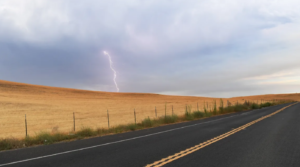
A lightning strike hits the surrounding hills near Marsh Creek Road in Brentwood, California, on August 16, 2020. [Photo: Jose Carlos Fajardo/MediaNews Group/East Bay Times/Getty Images]
This California Fire Chief is Building a Satellite System to Detect Wildfires As Soon As They Start
By Adele Peters, Fast Company, Sept. 16th, 2020
When thousands of lightning strikes hit Northern California in late August, the fires that sparked in remote areas weren’t detected until they had already grown.
The tiny bit of rain that arrived with the storm kept much of the smoldering low at first.
“It was only a couple of days later, as things dried out, that those fires really exploded into life,” says Dave Winnacker, fire chief of the Moraga-Orinda Fire District in the Bay Area.
The problem is common in the state’s sprawling wilderness: by the time a fire is noticed, it’s often already out of control.
Winnacker is now working with tech companies to develop and test a different approach.
Could low-Earth-orbit satellites, paired with software, find fires when they first begin?
Right now, satellites are used to track the perimeter of known fires. But as more low-Earth satellites—satellites that fly much closer to the Earth than traditional satellites—come online, they could also be used to detect fires at an early stage.
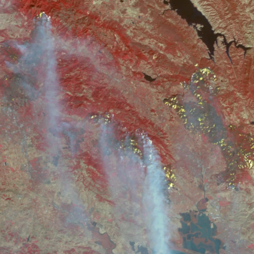
Thermal satellite imagery of fires in Northern California in 2017. [Image: NASA/Goddard Space Flight Center]
Wireless sensors in the tree canopy detected the fire as it began, then sent a signal to software that triggered a satellite to take a high-resolution photo of the spot.
“What we’ve shown is that in principle, we can not only capture a fire at its ignition but also begin to track it using satellites to track it robustly over every few hours, so that we see how fast it’s growing,” says Andrew Zolli, vice president of impact initiatives at Planet, the satellite company partnering with Winnacker.
The demonstration was just a first step. The data from the sensors is helping train the software working with the satellites, but eventually, as coverage from the new satellites expands, the satellites should be able to detect fires on their own by using AI to recognize the specific signatures of a starting fire.
That’s important since sensors in trees aren’t a feasible solution because of the enormous size of the forests they’d have to cover and the limited range of networks that connect them.
But Winnacker says that sensors could be useful when placed near homes at the edge of wilderness.
When residents have to evacuate because of the threat of a fire, sensors could potentially trigger sprinkler systems to automatically turn on if a fire approaches, helping protect homes as firefighters try to cover large neighborhoods with limited resources.
(The tech company Zonehaven, another partner, is also working with several other California fire chiefs to use sensors as part of a platform to create evacuation zones.)
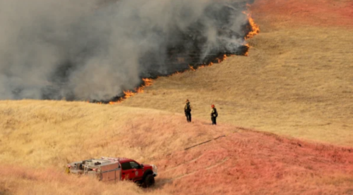
Fairfield firefighters watch over a slow-moving wildfire as it burns on a hillside behind homes in the Rolling Hills neighborhood of Fairfield, California, on August 19, 2020. [Photo: Anda Chu/MediaNews Group/East Bay Times/Getty Images]
“The end user that we have in mind here is potentially doing 50 miles an hour down a backcountry road in a Chevy Tahoe with two radios going loud, a cell phone that’s ringing, and an iPad on a bouncy mount as their primary means to which they can access information,” says Winnacker.
“How do we process the data, move it up the hierarchy of information by giving it context, and display it in a manner that’s digestible to that first responder?”
Firefighters don’t necessarily trust tech because it’s often unreliable when they’re working in the backcountry, he says, so it will be critical to make sure that there’s enough redundancy built into the system that first responders can always get live updates and trust the tech enough to truly adopt it.
If the new system can be put in place, it could be part of a larger shift to new practices that could help the West deal with the increasing risk of catastrophic wildfires as the climate changes.
Winnacker is also focused on managing lands differently—prescribed burns, for example, or removing some particularly risky vegetation, can also reduce the risk of megafires. But he’s embracing tech solutions.
(In another project with Planet, satellites are being used to map every tree in the state to help identify risky areas and take action.)
The work to develop the new satellite-based system is backed by funding from a philanthropic organization, the Gordon and Betty Moore Foundation.
“Like every other public agency, we don’t have an R&D budget,” he says.
“We don’t do these sorts of things. Government isn’t set up to develop stuff like this. And we just would not be able to do this work if it hadn’t been for their support.”
The next phase will require more backing from the tech companies that are involved.
“Now the challenge becomes convincing the folks who are actually putting money on the line that there’s a business case here, and that this is worth exploring,” he says. “But after the last couple of weeks, I don’t think we have to try very hard to get people’s attention. It’s topical and timely and relevant to all of the West Coast.”
Daily Smoke Viewing Technology
Smoke Forecast at FireSmoke.ca